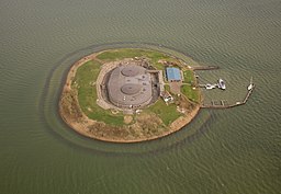
Fort Pampus in Pampus Island (left) and Fort bij de Liebrug, Haarlemmerliede (right)
Believe it or not, Amsterdam is surrounded by a 135 km long ring of fortifications located 15 to 20 kilometers around the center of the city.
It was constructed by the Ministry of War mostly between 1881 and 1914 and it was conceived as a waterline, which is a series of defensive fortifications separated by inundation areas. The intention was to flood these areas with approximately 40 cm height of water which would make it impossible for both ships and infantry to go through. However, the invention of airplanes and tanks made the forts obsolete almost as
soon as they were finished so the waterline was never used for its
original purpose.
Due to its value for humankind, the waterline was inscribed to the UNESCO World Heritage List in 1996 and many of the forts have turned into museums which can be visited. Some others are used for hosting charitable foundations, art studios, different hobby clubs and even restaurants. In fact, I rehearse with a choir in one of these forts: Fort bij de
Liebrug, in Haarlemmerliede and I live very close to the Fort of
Hoofddorp.
As you can see in the satellite map below, Hoofddorp is split into two by a large dike known as the Geniedijk
(Engineers' dike). If you want to see how all fortresses are connected, follow the dike in the map to the north-west and you will
find the fort of Vijfhuizen. If you go to south-east, you will see
the fort of Alsmeer. It is impressive, right?
View Larger Map
Lo creas o no, Ámsterdam está rodeada por un anillo de fortificaciones de 135 km de largo situado entre 15 y 20 kilómetros de distancia del centro de la ciudad. Fue construido por el Ministerio de la Guerra entre 1881 y 1914 y concebido como una línea de defensa militar con una serie de fuertes separados por zonas de inundación. La intención era inundar estas áreas con aproximadamente unos 40 cm de agua, impidiendo así el paso tanto a barcos como a infantería. Sin embargo, la llegada de los aviones y los tanques hizo que esta linea defensiva quedara obsoleta casi tan pronto como se terminó de construir por lo que nunca fue utilizada para su propósito original.
Debido a su valor para la humanidad, la línea de defensa fue inscrita como Patrimonio Mundial de la UNESCO en el año 1996 y muchas de las fortalezas son ahora museos que se pueden visitar. Algunas son también utilizadas por fundaciones de beneficencia, estudios de arte, diferentes clubes de aficionados e incluso restaurantes. De hecho, yo ensayo con un coro en uno de estos fuertes: Fort bij de Liebrug, en Haarlemmerliede y vivo muy cerca del fuerte de Hoofddorp.
Como se puede ver en el mapa de arriba, Hoofddorp está dividido en dos por un gran dique conocido como el Geniedijk (el dique de los ingenieros). Si quieres ver cómo se conectan todas las fortalezas, sigue el dique en el mapa hacia el noroeste y encontrarás el fuerte de Vijfhuizen. Si vas al sureste podrás ver el fuerte de Alsmeer. ¿A que es impresionante?
jueves, 7 de noviembre de 2013
Suscribirse a:
Comentarios (Atom)


